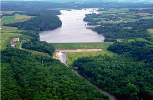
 Now I cannot do it justice but do want to show a nearby dam that is used for flood control. It may not look like much from the video but the area controlled is 222 square miles. So to speak it is like the watershed filling the pond. I wanted to get out to the dam when the water is running over the spillway but one of these times it will happen and I’ll get the video put up here with the one you’re about to see. In the video I mention the lake goes way back. Actually it goes back over 7 miles, wow that is a lot of water to control. Another part I was unsure of but found on the Army Corps site is that the overflow pipe is 19 feet in diameter, Wow. And with proper design and construction all the pieces fit together and work in harmony to keep folks safe from being flooded out, destroying homes
The Union City dam is used for flood control so the watershed above the dam is controlled and the farm land homes and roads below the dam are not affected by floods. This is very similar to retention ponds and storm water pond but a much bigger scale.
Planning out this project included picnic areas, restrooms a roadway and parking areas so there is more thought as to just putting in a pond. Look into the future, ask family, friends and neighbors their thoughts, it could spark up some ideas you haven’t thought about…
If you are in the area you’ll need to map out a trip to the Union City Dam and schedule time in to stop by WhatPond. A couple websites to see more detail are one from Union City, Pa. Community Website.

